
Sixteen Mile Creek, Gallatin County, Montana
Sixteen Mile Creek Summary
Sixteen Mile Creek (also known as Sixteenmile Creek), is a tributary of the Missouri River, in western Montana. The canyon through which it travels is known as Sixteen Mile Canyon. The abandoned grade of the Chicago, Milwaukee, St. Paul and Pacific Railroad (“the Milwaukee Road”) parallels the creek through the canyon. Milwaukee Road abandoned this line in 1980.
Sixteen Mile Creek begins in the Helena-Lewis and Clark National Forest, in the Crazy Mountains, in southeastern Meagher County. It flows generally west (through Gallatin County) and joins the Missouri River, 6 miles southeast of Toston (Broadwater County), at the site of Lombard, an old ghost town.
There have been a number of access issues along Sixteen Mile Creek over the years. Currently, PLWA is concerned about a bridge located in the Clarkston/Toston area. PLWA historically raised money to repair this bridge, but it was washed away a few years ago. A new landowner has successfully lobbied the County to not put in a replacement bridge. PLWA is working to coordinate a site visit and determine next steps.
UPDATE: July 2023
PLWA received another complaint in the 16 Mile Creek area. While attempting to access BLM land, a member of the public ran into a locked and posted gate. The county road sign for 16 Mile Road has been removed.
BLM and the County were contacted. They claim there is no easement for the public in place. The BLM routinely requests administrative access from the private landowners to complete maintenance, conduct surveys and assessments, and administer grazing permits on a section of land that is unreachable by the public.
More research is needed.
East Side
The east side of Sixteen Mile Road (Sixteenmile Road), the 71 Ranch, owned by the Galts, have a locked gate and prohibitive signage to block public access. This portion of Sixteen Mile Road is on the northwest side of the Crazy Mountains, Meagher County, leading into Custer Gallatin National Forest public lands. Per the USFS Travel Plan and Motor Vehicle Use Map for the Custer Gallatin National Forest, Crazy Mountains, FS Road 991 is a “road open to all vehicles”. FS Road 991 extends west beyond the Forest Service boundary, through private property owned by the Galt’s 71 Ranch, connecting to the Sixteen Mile county road.
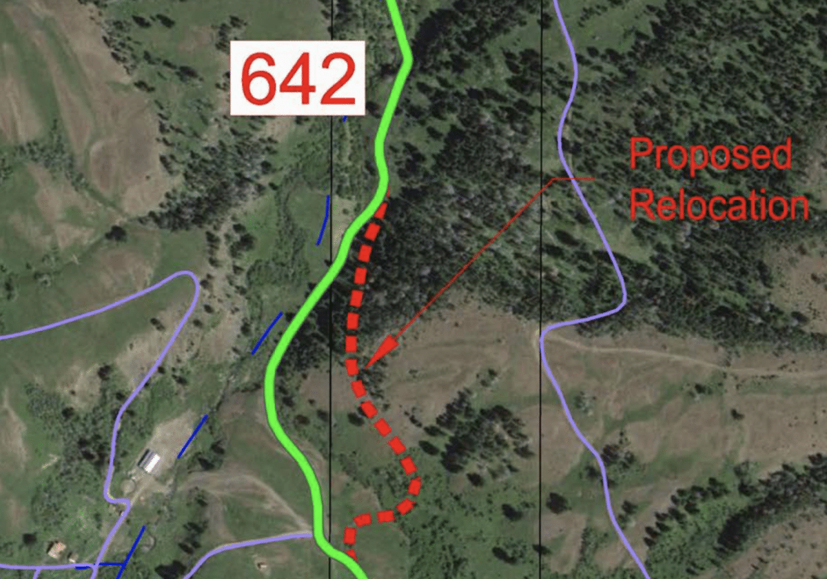
South Fork – ACCOMPLISHED
The South Fork of the Middle Fork of Sixteen Mile Creek, there was a private land parcel without a Forest Service easement. FS Road #642 allowed motorized access, winding through Forest Service and private lands in the Bridger Mountains, just southeast of Horse Thief Mountain.
In 2012, John Logan from Prentiss, Mississippi (owner of Brinson Farms LLC) bought 130 acres of land within the Bridgers. He then set up an outfitting business on it: Big Sky Outfitting. A locked gate was then installed, blocking the public from accessing the public lands further up FS Road #642. After a number of public complaints and unsuccessful landowners negotiations for an easement, the Forest Service decided to reroute the road, away from Sixteen Mile Creek, totally onto Forest Service land to restore access and a better quality road (away from the creek).
In October 2016, the FS began the Middle Fork Sixteen Mile Road Relocation Project Environmental Assessment. In June 2017, the FS published their Decision Notice and Finding of No Significant Impact. Thanks to the public sending in comments to restore access, the Forest Service moved ahead with the FS Road #642 rerouting to restore public access.
Proposed FWP FAS
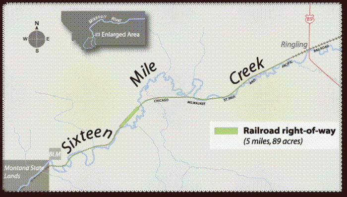
Efforts began, in 2006, to acquire 5 miles of railroad right-of-way stretching west from Ringling along Sixteen Mile Creek. On July 18, 2012 Montana Fish, Wildlife & Parks put forth a proposed action: Decision Notice for – Sixteenmile Creek Fishing Access Site Proposed Acquisition and Development Draft Environmental Assessment. The proposal was to acquire 89.16 acres of land along a five-mile stretch of abandoned Milwaukee Railroad right-of-way approximately one mile west of Highway 89 and one-half mile west of Ringling, Montana, for the purpose of developing a day use fishing access site (FAS) on Sixteenmile Creek. FWP also proposes to construct a parking area for approximately eight vehicles at the eastern end of the property, an access road to and fencing around the parking area, installation of a vault latrine, and directional and informational signs.
During the 2010 and 2012 comment periods, FWP received a total of one hundred and forty six (146) comments regarding the proposed action; one hundred and twenty three (123) comments supported the proposal, and twenty three (23) comments opposed the proposed action. Based on the Environmental Assessment, public comment, and FWP evaluation, Region 3 Supervisor Pat Flower’s decision was to proceed with Alternative B, the proposed action of acquiring 89.16 acres of land for purposes of establishing a fishing access along Sixteen Mile Creek.
However, there was an issue with a clear title for the property, no record of the easement was found and the proposal fell to the wayside.
UPDATE: July 2008
Efforts underway since 2006 to acquire 5 miles of railroad right-of-way stretching west from Ringling along Sixteen mile Creek, and accessing an otherwise isolated section of DNRC land for another mile, are now nearing conclusion. Funding has been provided by the Montana Fish and Wildlife Conservation Trust, and the land is under contract with the Western Rivers Conservancy to act as an intermediary. It’s now up to Montana Fish Wildlife and Parks to complete the land acceptance process and close the deal
However, we understand local landowners appealed the EA with FWP, and have raised legal issues challenging validity of access to property. We understand the Conservation Trust running out of patience with funding commitment. At best we may have one more year to make this happen.
Past public support from sportsmen for this project has been overwhelmingly positive, and essential in moving it forward. A February/March Northwest Fly Fishing article on Sixteenmile Creek mentions this acquisition and quotes a FWP staffer saying “The proposed project generated more public comments than any other project in my entire career.” Your continued support will help make fishing access to this fabled and historic water a reality. It’s time to push this to a conclusion.
A second round of public comments closed April 30, 2012. From what we understand thousand of comments were again received and have been evaluated by Region 3 of Montana FWP. We understand the comments have been about 2/3 positive but as usual, the local nearby landowners are negative. FWP staff who are directly involved with this project include Allan Kuser, Pat Flowers, Ray Heagney, and Travis Horton. Jeff Hagener FWP Director, is also well aware of this effort. A “Notice of Decision” on the EA has been approved by R3 director Pat Flowers. This decision is subject to appeal for a decision by FWP Director. We do expect it will be appealed. If the resolution of that appeal is still protested, the matter could be pursued in the courts. After all that, this must be approved by the FWP Commission, and subsequently by the Land Board.
FWP Biologist Ray Heagney, the point person on this at R3, can be reached at 406-994-4042. PLWA member and Big Sky resident Steve Johnson at 406-539-6660 is also active and knowledgeable about the project.
Without the Montana Fish and Wildlife Conservation Trust this would not have been possible. This trust was set up by Sen. Max Baucus to hold funds coming from sale of Canyon Ferry cabin lot lease holders. PLWA President John Gibson serves on the trust advisory board which recommended allocation of income to this project. The appraised value and purchase price of the property is $315,000.
At the Meagher County Commissioners hearing, some of the locals said the acquisition was a bad deal because “there are no fish in there”. However, here is what a real estate ad for a near by property had to say:
“The live water on the property can only be described as exceptional. It is very rare in Montana to find truly private trout water with Montana stream access laws. Fishing on Sixteen Mile Creek Ranch is virtually private water; anglers can fish this property all season and not see another person, let alone another angler. This is due to the large landowners that surround Sixteen Mile Creek Ranch and the limited access. Pick your favorite dry attractor or terrestrial pattern and head out for a day of some of the best top water action found anywhere. At about 25 feet wide, Sixteen Mile Creek is the classic fishery to wear your wading sandals and walk the creek casting 15 to 30 feet to eager trout. The fish do not pay attention to anglers, thus are quick to take any well-placed offering. “
Sixteen Mile in Maps & Pictures