EAST CRAZIES LAND EXCHANGE
ACTION ALERT-MARCH 2024
PLWA continues to oppose a complicated National Forest proposal to consolidate checkerboard public lands on the east side of the Crazies as part of a land exchange facilitated by the Yellowstone Club; arguably the most elite private enclave in Montana. The East Crazies Inspiration Divide Land Exchange (ECIDLE) is a public lands saga nearly a decade in the making. With a key decision sitting before Congress, and few options available to appeal the decision, we need your help to make our collective voices heard!
The clock is ticking in the Senate and House Congressional Appropriation Committees with an April 3rd approval deadline for the East Crazies Inspiration Divide Land Exchange (ECIDLE). Land exchanges valued over $1 million are required to get direct Congressional approval and we have a short window of opportunity to comment before this proposal is signed and sealed.
It’s crucial that you contact your Montana Congressional Delegation today and let them know you oppose this raw deal. Moving ahead with this proposal is an injustice to the public and all who have spoken in opposition to this project.
Sample statement
I oppose the East Crazies Inspiration Divide Land Exchange and urge you to stop the Forest Service from approving this raw deal that permanently puts public access at risk in the Crazy Mountains. The Forest Service has ignored the recreating public, please do not do the same.
Additional talking points
This proposal relinquishes claims on parcels of public lands AND forfeits granted USFS easements to the public.
Montana conservation groups are all aligned in opposition to this proposal.
There are massive discrepancies between the stated goals of the land exchange and the objectives that would be achieved.
The lack of transparency from the USFS, closed door negotiations and failure to make concessions, has completely eroded the public’s trust in the process.
Please see PLWA’s website for more information and our previous actions and positions related to the ECIDLE.
Email your elected representatives today and tell them to Save the Crazies!
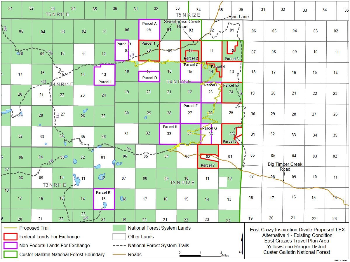
Forest Service map of the “preferred alternative” for the proposed land exchange in the East Crazies.
PLWA Comments on East Crazies Inspiration Mountain Land Exchange
JANUARY - FEBRUARY 2024
In late 2023 / early 2024 the organization as well as other objectors of standing were notified that the US Forest Service had decided to take the unusual step of holding an Objection Resolution Meeting, whereby the USFS and Objectors could discuss noted objections to the plan in more detail. That e-mail is available here. This meeting was to be a closed meeting for individuals who had registered objections with the USFS and were speaking on behalf of members, groups, or communities. An invitation to a closed meeting was issued and several parties were invited. The second e-mail is available here. The day before the meeting guidelines were issued by the USFS regarding “ground rules” and an agenda which are available here and here. PLWA was joined in objections by:
Wild Montana
Montana Wildlife Federation
Backcountry Hunters & Anglers
Park County Environmental Council
Friends of the Crazy Mountains
Park County Rod and Gun Club
There were also six individuals who spoke in opposition to the ECIDLE, the majority of them PLWA members. All but one of the individuals is listed in the agenda.
All of the Objector organizations were able to meet beforehand and discuss common issues with the ECIDLE, and the importance of engagement and transparency in the process. What was striking was the incredible alignment and cooperative spirit of all involved to ensure the USFS heard both the Objectors’ voices, and took seriously the concerns of the communities we represented. There was also grave concern that the process was being obfuscated and obstructed.
The incredible importance of protecting the Sweetgrass Drainage access was a common theme and PLWA also supported the incredibly important points made by partners and speakers regarding necessary conservation easements and clarity regarding process.
Disturbingly, at the beginning of the meeting, Objectors were told that they were not permitted to discuss any requests for legal action to secure or protect public access into the East Crazy area of the land exchange. Meeting attendees were also told that the meeting would not be allowed to be recorded in an effort to further productive conversation. Speaking on behalf of PLWA and its membership, Drewry Hanes called USFS staff and attendees’ attention to the discrepancies between the stated goals of the ECIDLE and the objectives achieved in the exchange. She also questioned how relinquishing claims on parcels of public lands and trail mileage that is currently public could serve to increase public access, as stated in the proposal. The forfeit of USFS easements granted by the Van Cleve Company to the public was also concerning to PLWA. Upon questioning by USFS staff about the existence of these easements, Ms. Hanes produced copies from the department’s own files and offered them for review. This is available as Appendix 1 in documents supplied in our initial objections below.
PLWA received, with other Objectors, official correspondence from the USFS regarding this matter a few short weeks later, noting that while all Objectors were consistent with their concerns, the USFS would be moving ahead with their proposal unaltered. That is available here. PLWA is pursuing the matter of access in the East Crazies independently and hopes to have more news soon.
SEPTEMBER - NOVEMBER 2023
PLWA opposes the proposed East Crazies Inspiration Divide Land Exchange.
The comment period on the drafted response has closed.
Read PLWA’s full comments HERE.
PLWA’s summary comments are that our organization has concerns regarding:
The seeming preference shown by the USFS for satisfaction of private landowners in the proposal over that of public access and conservation objectives;
The ceding of Sections 8 and 10 [S08, T04N, R12E and S10, T04N, R12E or Sections 1 & 2 in the PEA land swap designation] and the unclear nature of the ability for deed restrictions to achieve the stated objectives of the agreement;
The rationale for valuing speed of process in order to obtain financial gain over the possibility of securing potential public access; the proposal’s ability to maintain high quality areas of recreation and wildlife habitat currently enjoyed by the public;
The degree to which the current proposal undermines objective 5430.2 of the Forest Service Manual.
USFS RESPONSE DOCUMENTS
Comment Consideration and Response
20230927Map_Alternative1ECrazy
NOVEMBER - DECEMBER 2022
The following are the Public Land Water Access Association’s (PLWA) formal comments on the Preliminary Environmental Assessment (PEA) for the East Crazy Inspiration Divide Land Exchange (ECIDLE).
Among PLWA’s organizational access objectives are:
Monitoring public land sales, exchanges, and purchases to ensure that no transfers are made without full consideration of conservation and recreational values;
Monitoring public access routes and identifying access issues; and
Pursuing every legal and ethical avenue to protect and maintain access to public lands and waters.
The Public Land Water Access Association has a long and proud history of working as a facilitating party in land exchanges and enhancing public access in concert with private landowners, government bodies, fellow nonprofits, and the public. We believe that through detailed research, reasonable compromise, and careful stewardship of our natural resources and public lands and waters, Montana thrives. PLWA has been working on issues in the Crazy Mountain region of Montana for over twenty years, and agrees that there are numerous challenges involved. We also recognize the work that public and private individuals and groups have dedicated to this process on the East Side of the Crazies. However, the current Preliminary Environmental Assessment misses the mark, failing to complete the required due diligence regarding public access, and failing to safeguard the public interest at the broader level. It also sets a dangerous access precedent of “something is better than nothing”, which mistakenly portrays the public as coming to the table empty-handed.
POSITION
At this time, PLWA formally opposes the Preliminary Environmental Assessment for the East Crazy Inspiration Divide Land Exchange (ECIDLE). We will detail some of our concerns below.
Specific Comments
1.1 Introduction; Figure 1 [Pages 1, 3-6]
Comments:
1. In neither the background nor indicated on the map in Figure 1 does the PEA include the historic easements held by the Forest Service for traffic by the public on Sweetgrass Trail [Appendix 1]. Also absent from the provided information are the Northern Pacific Railroad federal patents and deeds to private owners for Township Four North, Range Twelve East in the Sweetgrass Basin, which include the reservation that lands conveyed are subject “to an easement in the public for any public roads heretofore laid out or established, and now existing over and across any part of the premises.” These deeds and patents are recorded for sections 7, 9, and 11 (among numerous others relevant to the land exchange under discussion) in Township Four North, Range 12 East [Appendix 4]. Taken as a whole, the publicly held Sections of 8 and 10, along with the portions holding federal railroad patents and reservations, form a coherent section of land between sections 7-12. In light of the PEA’s goals of forming “contiguous parcels”, these issues should be addressed and noted in the PEA.
2. By relinquishing public Sections 8 and 10 (T4N, R12E) in the Sweetgrass Basin to private hands, and without placing any conservation easements on the use of this access point long utilized by the public, the action of the PEA is in direct conflict with its second and third objectives to: (a) “preserve and enhance the quiet, undeveloped, unroaded characteristics and associated social and ecological benefits including public recreational opportunities, conservation of biodiversity and improved habitat connectivity”; and (b) “conserve the existing character of the Crazy Mountains by reducing the potential for development on 10 sections of private lands interior to and comingled with NFS lands”.
a. Per the satellite image provided [Appendix 2] it is clear that there is a road running through this area that receives use currently and has received use through the past decades. In fact, this has served as a wagon road over the past century. Ceding these parcels into private hands would seemingly only increase the ability to use this area for motor traffic and remove restrictions on development. Additionally, the areas in Parcels 8 and 10 are currently available for hiking and camping which is comparatively low impact ecologically. Per Forest Service trail work employees, the only concerns raised historically which would negatively impact the area environmentally have been grazing and cattle. It is likely that these negative impacts would only increase with the transfer of public lands into private hands paired with the loss of Forest Service employees available to help mitigate these issues [Appendix 3].
3. In the PEA on Page 4, the document states: “these elements are outside of the Agency’s decision on this exchange and as such will not be evaluated in this document…The proposal respects the status quo regarding permissive public access into the upper Sweet Grass Creek Drainage over Rein Lane. The landowners have indicated that they intend to continue allowing permissive seasonal access across the private lands they own, so long as private property is respected.” [agency emphasis, not author’s] These statements are at best arbitrary and capricious. The document attempts to provide a history of use and status of the road, yet as noted in this comment document, it is incomplete. It should be noted that if a proposal to trade away public lands is proffered, then certainly it falls within the scope of the overseeing body to include relevant information and a framework to evaluate the elements involved. The argument that a status quo can function as a proxy for any legal or reasonable starting point is specious, and misleads the public about the issues and facts at hand. Lastly, it is important to recognize that without formal recognition of rights and responsibilities of the land recipient, neither the public nor private landowners are guaranteed anything, and as such all promises should be considered moot.
a. Note: It is unclear why these caveats regarding Sweetgrass are included in negotiations involving the Inspiration Divide area and parties engaged with said subsection, other than landowner special interest, but as such they are addressed here.
4. Multiple historic maps show the road and trail into the Sweetgrass Basin area over the past century. [Appendix 5]. It is noted that there was a schoolhouse used by children in the area back behind what was the Brannin Ranch (Bachelor Schoolhouse), and that it was located past Rein Lane in the 1920s and 1930, (Sweetgrass School District #4). [Appendix 6] It is noted by the owners living in the area previous to the Carrocias that in the 1930s they had a contract with the Forest Service to mill timber and that a Forest Service cabin was built to enable this. Logs were sold locally to home owners in the valley. There is also a history of road and trail maintenance by the Forest Service in Sweetgrass.
a. “Ours was the last place on the Sweet Grass, and then a logger’s cabin was built on the Forest Section about three-quarters of a mile west of Gommie’s Lake and maybe a quarter of a mile beyond Ward and Parkers’ boundary fence. The cabin was located down under the hill below the road. It was put up in the fall or late summer and was right next to the steep bank that led up to the road. Billy Briner and two Reynolds boys from Melville were the first residents. They had a log contract for two dollars a thousand feet. That would give them more than a dollar a day for each one, which was a dollar more than they could make any place else in those depression days…They moved back to town and Riley Doore became their replacement…The round-roofed cabin was well protected from the wind, and it faced the south. This suited the needs of Briner and Doore as they reduced forest service trees to ten, twelve, fourteen, and sixteen-foot logs. They were allowed to scatter the tree limbs, but the top of the tree stumps had to be no more than fourteen inches from the ground…Riley Doore and Billy Briner batched all winter in the cabin. Sometimes they hiked the mile and a half down to the sawmill or the next two miles to the Brannin Ranch. The water in the Sweet Grass rose, and a fresh water spring creek sprung up beside the bank. That summer the Forest Ranger marked more trees. Another logging crew was needed. Two young Swedes came down from Canada.” [Retrieved 11.30.2022]
b. Records in the form of letters and receipts show a history going back to 1930 and possibly earlier for maintenance of the Sweetgrass Road and Sweetgrass Trail and East Trunk Trail, with multiple use intention. There were various agreements and cost and work shares with the Forest Service and land owners over the past century for Sweetgrass Road and Sweetgrass Trail. [Appendix 7]
5. Most opinions regarding whether access is available to the public seem to be reactionary in regards to access being closed off by landowners rather than a new policy by the Forest Service or serviceable facts coming to light. There are opinions expressed from USFS employees and residents both ways and documented over the past century, most opinions against access contained within the past 28 years. Per internal e-mails within the Forest Service, even as late as 2014 it was the advice from the Office of General Counsel (USFS’s legal advising body) that the trail and road represent an interest in legal access and should be pursued and noted as points of access for the public and USFS employees. As such, this discussion merits inclusion in the EA. [Appendix 8] Additional opinions from landowners in the area seem to dispute that these roads and trails have been precluded as private over the past 50-100 years, and even the past 10 years. [Appendix 9, Appendix 10]
There are, throughout the history of use in the East Crazy recreational area, additional back and forth statements between the private individuals and the Forest Service, with changing policies and points of view regarding access to the East Trunk & Sweetgrass Trails and Sweetgrass Canyon, mostly dictated by the needs of public and private individuals and any obstacles current at the time. However, what is clear is that there is a strong pattern of use by the public going back to the earliest days of hunting and trapping in the area and of maintenance of the roads and trails. There is also a clear value by the public and private landowners of the lands and waters included in this area of the Crazy Mountains that must be addressed by the PEA.
1.3 Need for Action [Page 7]
Comments:
1. Objective 3 states a need to create “perpetual public access”; however, as noted previously, a promise by the current landowners to provide limited access as they see fit in no way serves this objective. The land could be immediately sold with no guarantee this promise continues, and it could be rescinded at any time. Currently, the public also enjoys access to two sections of Sweetgrass Drainage, including Eagle Park which has been previously identified as an ideal location for a USFS campground by Forest Service leadership. Losing this would mean a permanent loss of access with no ability to reconsider.
1.5.1 Federal Regulations [Page 10]
Comments:
1. As one articulated goal is to “achieve the optimum land ownership pattern to provide for the protection and management of resource uses to meet the needs of the nation now and in the future (FSM 5402.1)”; it seems contrary to propose a PEA that omits conservation easements, and one that codifies public access that is very likely less than what is now held by the public, especially with an anticipated growth in use patterns.
1.5.2 Land Management Plan Consistency [Page 11]
Comments:
1. Enhancing recreation, public access, and protection of aesthetic values is stated in the goals of this section. By losing access to two parcels (Parcel 8 and 10 in the Sweetgrass Drainage) and the two trail easements held there, the public loses out on both access and recreational opportunities. This also represents, within the scope of the Crazies land area included in the PEA, some of the most ecologically diverse area as well. Ceding these lands and waters, especially without reservation of any conservation easements or access easements, seems to directly decrease recreation, decrease public access, and fails to protect aesthetic values of the Crazy Mountain district and the area within which the public is able to recreate. Of note, conversely, this does seem to serve to enhance recreation for private land and water users, enhance recreation for private individuals and those paying for outfitting, dude ranching, and other services, and may or may not provide aesthetic values to the land owners engaged in the process and those they provide business services for. It should also be noted that if this land is sold or developed, all three of these objectives could be compromised in the near or distant future. It should again be noted for the record, the current trade also forever eliminates from consideration the Forest Service’s previous assessment of Eagle Park (Exchange Parcel 1; S08, T04N, R12E) as an ideal location for a USFS campground, and likely the only suitable location for an additional site within this area of the Crazies.
2.2.1 Additional Elements of the Proposed Action [Page 12]
Comments:
Regarding the following statement: “The parties will eventually develop and enter into a more detailed agreement regarding the trail and trailhead improvements and identify each party’s roles and responsibilities.”
1. It is unclear to PLWA why at this point and seemingly throughout the document the promises made to the public about public access, trail maintenance, and preservation are not detailed and clearly delineated at this late a stage. What is the utility of such an exhaustive document and plan if it omits such essential elements that fall within the sphere of public interest, especially when items such as outfitting and special use permits have been exhaustively documented?
2.3 Alternatives Considered but Eliminated from Detailed Analysis [Table 8 – Page 18]
Note that the Direct Right of Way/Easement Purchase regarding Rein Lane and Sweet Grass Trail East Trunk Trail and Smeller Lake Trail are still in question, and that the satisfaction of these issues is not at the sole discretion of the land owners involved.
Comments:
1. The dichotomization of consolidation of lands vs. access portrayed here is not distinctly accurate. There is omission of the current easement held on Sweet Grass Trail, and the historic access on Rein Lane (previously Sweet Grass Road). Also as noted previously, the current proposal is to a notable degree contrary to many of the stated objectives in its current form.
3.2.1 East Crazy Travel Plan Area Access [Page 27-28]
Comments:
1. As noted clearly in the section, the summary action suggested which does not reserve Parcels 1 and 2 [S08, T04N, R12E and S10, T04N, R12E] for administrative or public use violates the objectives previously stated in USFS Travel Plans, as well as those stated within the PEA (previously articulated), and disregards the easement for the trail held by the Forest Service and the position of OGS and Forest Service Employees articulated publically and in internal communications. [Appendices 1, 7, 8]
a. Clarification – does the listed Sweetgrass Road No. 900 refer to the previously listed Sweetgrass Road No. 990 in the same sub-section?
Land Management Plan Direction - 2006 Gallatin Travel Plan Decision Access Direction [Page 32]
PLWA holds that in its current form, the PEA fails to meet OBJ. B-2 Acquire All Rights Needed.
Comments:
1. The very nature of this objective infers that it is necessary for the USFS not to simply articulate the status quo with regard to access, but rather to perform due diligence about the public’s historic use patterns and possible access, broadcast future access needs, and acquire access and rights needed. This is an inherently proactive objective, and cannot be satisfied without the due diligence suggested by further examining the Sweetgrass Drainage issue.
LMP 2022 Desired Conditions and Goals (FW-DC-RT) [Page 33]
Objective 01 addresses the need for the transportation system to provide “safe and efficient public, private inholding, and administrative access to the Custer Gallatin for recreation, special uses, forest resource management, and fire management activities”.
Comments:
1. The area of Sweetgrass Road and the drainage which would be ceded to the private entities involved has at various times during the past decade, been closed off with a locked gate. During these periods, the Forest Service has at times had keys to the gate concerned per various agreements with land owners. [Appendix 11] The majority of the time no permission has been sought to enter or there has been no encumbrance. However, at other times access has been encumbered.
a. Note that though there is a foot and horse traffic restriction for the public on the easement held by the USFS in this drainage, there is in actuality a road running up to the private land parcel [S07, T04N, R12E] through public land Parcels 8 and 10 [S08, T04N, R12E and S10, T04N, R12E] used by private individuals.
2. In 1918, a fire ripped through the Sweetgrass area and the Crazy Mountains. The magnitude was so devastating that “the scars of the fire dominated the valley for thirty years. Half of the available timber had burned.” [Retrieved 11.30.2022][Appendix 12]
a. “The Forest Service offered a permit to salvage the burned timber. The sawmill was set up on the shady side of the creek and a temporary cabin built on government land in a clearing at the foot of a burnt mountain…The mountain land not already settled was divided between the Northern Pacific Railroad and the National Forest. This meant setting up a sawmill on government land on the south side of the mountain about half a mild southwest of the Brannin holdings.” [Retrieved 11.30.2022]
Of note, this fire is still talked about over 100 years later. Should the Sweetgrass Basin area be traded into private hands, especially without an administrative easement or access, this constitutes a public health risk due to the lack of access for firefighting. Should the residents be away and unable to provide access, should they block access by a means by which firefighting crews cannot gain access, or should they deny access at a critical moment, this could spell disaster not only for the area but for the safety of residents throughout the Crazy Mountain residential district. This area falls into a category area with remarkable fire risk per the USDA. [Appendix 13]
This section also notes that “The trail system accommodates current and reasonably foreseeable recreational demands.”
Comments:
1. As previously stated by PLWA and reiterated by USFS employees at the Bozeman listening session on November 14th, 2022, there is an expectation that hunting and other recreational traffic should increase if the PEA is approved. With an increase in the number of recreationists and a decrease in access (with the Forest Service’s election to relinquish rights on the Sweetgrass Trail and trade away two public sections), we should anticipate an increase in crowding at the access point at Big Timber Canyon to the south. This will likely lead to more traffic and parking issues, trail use being higher especially within the first few miles of the trailhead and bottlenecking, higher ecological impacts upon flora and fauna, and an inverse relationship between public access opportunities and private access opportunities. PLWA does not see these issues well addressed in the current proposal.
3.3 Recreational Uses; Developed, Dispersed Recreation and Trails [Page 36]
Comments:
The PEA states that “The Sweet Grass Trail is a long out and back trail with no scenic destination. Current use levels are low with the most use occurring during the fall hunting season.” PLWA finds this statement misleading for several reasons.
1. It is true currently that the Sweet Grass Trail is an out and back and that the use is low. However, both of these findings hinge on the fact that passage via the Sweetgrass Road has been hindered and public access obstructed. Should this not be the case, then 50% of access to the Crazy Mountain recreation area would be available to the public, making this trail and area an important and popular area.
a. Notably, this would also serve to decrease the incredible ecological impact of having all traffic routed through the southern, Big Timber access location.
b. Additionally, out and back trails hold high value within the Forest Service. For example, the most popular Gallatin County trail is the 10.9 mile Hyalite Creek Trail which is an out and back.
2. The argument against Sweet Grass Trail’s aesthetic value seems antithetical to its history of use.
a. There has been a history of use up to present day of members of the public utilizing the area for camping and hiking and the river/waterfalls in and outside of hunting season and appreciating the area. [Retrieved 11.30.2022] [Appendix 14, Appendix 15] The aesthetics of the area are provided for review.
3.8 Cultural Resources; Effects of Proposed Action [Page 54]
Comments:
Per CFR 800.5(a)(2)(vii) the transfer of the involved parcels at this point is being conveyed without the required evaluation that would “ensure long-term preservation of the properties’ historic significance” and any mitigation required as a result of these investigations.
1. As shown previously in these comments, there exists a strong historic precedent of use in the Sweetgrass Basin area for Federal and public commercial use, a myriad of historic buildings, an over century long history of hunting and recreation, as well as USFS and public interest in recreational preservation and enhancement.
4.0 Agencies and Persons Consulted [Page 57]
Comments:
Throughout the PEA, commentary has been present about the length of time it has taken private and USFS individuals, as well as arbiter organizations to come to an understanding and engage in the process of compromise. In this light, it is concerning to PLWA that the PEA has been timed to engage in public discourse in the manner which it has been.
1. The PEA was published online November 9th, 2022. The document is 63 pages in length. Listening sessions were announced online for Tuesday, November 15th in Bozeman and Wednesday, November 16th in Big Timber, less than a week after the PEA was made available for review.
a. This short window to review a document of this length and formulate appropriate questions at listening sessions is concerning to PLWA.
2. Letters were mailed out to the “organizations who have expressed interest in past projects within the Crazy Mountains”. The letter sent to PLWA announcing the listening sessions was dated November 9th, 2022 (the date of publication of the PEA). The letter was postmarked November 29th, 2022, twenty days after the publication and two weeks after the listening session had already concluded in Bozeman. PLWA has concerns about the good faith this represents with regard to opportunities for public engagement. [Appendix 16]
3. The PEA comment period occurs within the bounds of US Thanksgiving and Christmas, the two busiest travel holidays of the year, and the two periods within which the majority of US businesses schedule breaks in service. There is no period within which the assessment and comment period could have been scheduled to make it more difficult for public engagement to occur. This is concerning to PLWA.
a. Note that the site for comments has been down during the December 20th, 2022 period, making comment submission difficult.
Final Comments
PLWA would like to finally reiterate that our organization has concerns about:
1. The lack of due diligence performed regarding pursuit of and protection of public access at Sweetgrass Road;
2. The ceding of Parcels 8 and 10 [S08, T04N, R12E and S10, T04N, R12E or Sections 1 & 2 in the PEA land swap designation] and relinquishing of the easements on Sweetgrass Trail by the USFS;
3. The increasing impacts that would be felt upon flora, fauna, and users if 50% of the possible access points into the East Crazies were eliminated;
4. The lack of codification of access rights and conservation planning included in the PEA;
5. The PEA’s seemingly contrary effects when taking into account its stated objectives;
6. The risks to future recreation and conservation should the PEA move forward in its current form.
We appreciate the work contributed by the many members of working groups and those serving in a professional capacity to enhance recreation in Montana. At PLWA, we believe that conservation and compromise are important, but that to preserve the distinct nature and quality of the place we call home, public access is everything.
December 23, 2022
The Board of PLWA The Staff of PLWA
Bernard Lea, President Drewry Hanes, Executive Director
Matt Lussier, Vice President Haley Sir, Public Access Investigator
Carol Fox, Secretary Ashley Helm, Director of Volunteer Services
Katy Ross, Treasurer
John Gibson, Board Member
Chad Zeitner, Board Member
Amelia Flanery, Board Member
Kevin Frazier, Board Member